
Heat alerts affect over 100 million people in 15 states from the western U.S. to South Florida
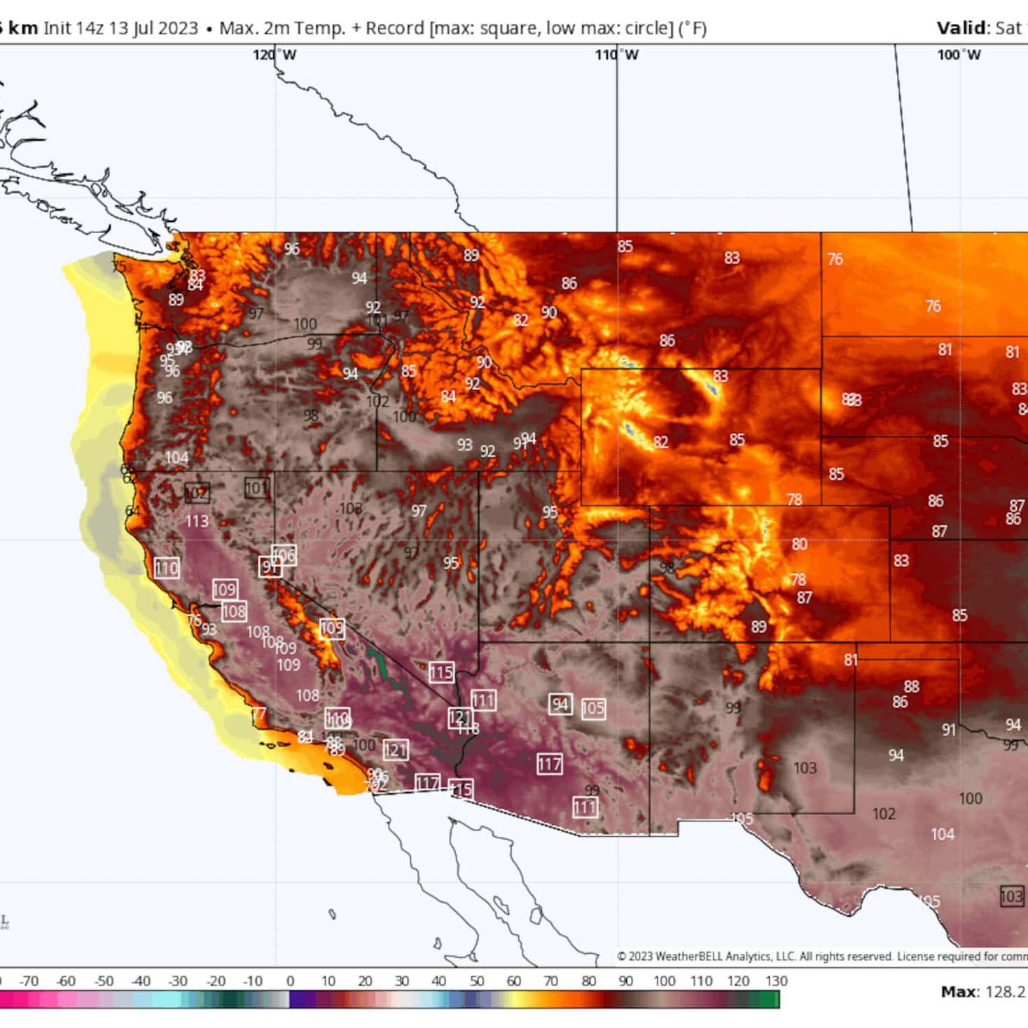
A massive coast-to-coast heat dome is sprawled over the western and southern United States and is forecast to strengthen into the weekend. It’s generating soaring temperatures that are poised to approach all-time records in Phoenix, Las Vegas and California’s Central Valley and surpass 130 degrees in Death Valley, Calif., the heat capital of the world.
In many areas, the longevity of this ongoing heat wave is more remarkable than its intensity. Some locales have seen no relief from dangerous temperatures for over a month, and this heat wave shows no signs of relenting soon.
Excessive-heat watches and warnings or heat advisories affect over 100 million people and cover 15 states from Washington state to New Mexico, including Arizona and California, and from Texas to Florida.
In the West, it’s a blistering, dry heat that presents a growing risk for dehydration.
“Dangerous heat will result in a major to extreme risk for heat-related illnesses for much of the population, especially those who are heat sensitive and those without effective cooling and/or adequate hydration,” wrote the National Weather Service in Hanford, Calif. Excessive-heat warnings are in effect for much of California’s highly populated Central Valley, where highs could reach 117 degrees.
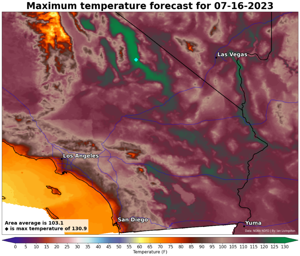
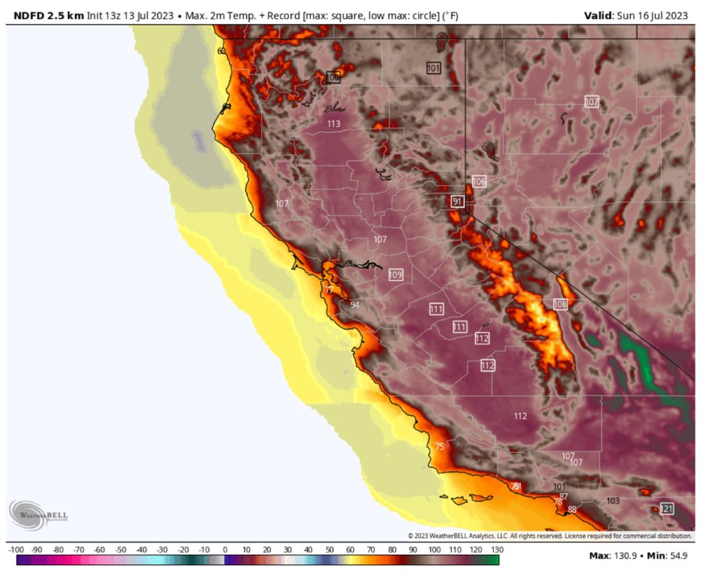
Death Valley could challenge the highest temperature ever reliably measured on the planet. The heat-prone site may make it above 130 degrees over the weekend, surpassing the record mark previously set at the same location in July 2021 and August 2020. Nighttime low temperatures in Death Valley are forecast to exceed 100 degrees.
Across the southern Plains, Deep South and Southeast, tropical moisture will overlap with hot weather to make heat exhaustion and heat stroke a dangerous threat. Heat indexes could climb into the 110-to-120-degree range. Marathon Key, Fla., just netted its hottest five-day period on record, with an average afternoon high of 97.2 degrees. Wednesday featured a heat index of 118 degrees. Unprecedented water temperatures between 94 and 98 degrees are also threatening sensitive corals and marine life.
The heat is not confined to the Lower 48 states. Southern Europe is also in the early stages of a dangerous heat wave. Excessively high temperatures are forecast from Portugal and Spain through southern Italy and as far east as Romania and Bulgaria on Thursday and Friday.
In Sicily and Sardinia, temperatures could approach 118 degrees (48 Celsius), challenging the highest levels ever observed in Europe, according to the European Space Agency. The heat will expand into Central Europe, including Germany and Poland, over the weekend and may linger over southern Europe for much of next week.
A punishing dry heat in the Southwest U.S.
It’s not just Death Valley facing all-time records. Sunday is expected to bring a high of 117 degrees to Las Vegas, which would tie the city’s hottest temperature ever recorded. There’s a chance that Saturday, Sunday, Monday and Tuesday could also tie a record-long streak (four days in 2005) of afternoon highs at or above 115 degrees.
In California’s Central Valley, highs will peak between 12 and 15 degrees above average both days this weekend, generally between 108 and 113 degrees. Sunday’s highs have the greatest propensity to shatter records far and wide. A few record-warm overnight lows are also anticipated as temperatures fail to fall below 75 degrees in spots.
Interior Southern California will also swelter. “A dangerous, prolonged heat wave is in store for inland areas through at least early next week, with the hottest days Sat[urday] through Mon[day],” tweeted the Weather Service forecast office in San Diego.
Phoenix, meanwhile, arguably the most heat-prone city in America, established a record warm nighttime low of 94 degrees Wednesday and is poised to set numerous additional records.
The most popular and interesting stories of the day to keep you in the know. In your inbox, every day.
Phoenix has already logged 13 days straight with highs at or above 110 degrees and is closing on the record of 18 days which should be surpassed early next week. Every day in the seven-day forecast for Phoenix calls for highs of 112 or greater.
By multiple metrics — including record-warm nights (already three in a row of 90 degrees or hotter) — this is already the city’s worst heat wave on record, and the hottest days are still to come. On Saturday, Phoenix may hit 118 degrees, with an outside chance of 120.
Over the next week, the Weather Service is forecasting an average temperature (of high and low temperatures) of 104.6 degrees in Phoenix, which would crush the city’s previous warmest week on record, which had an average temperature of 102.9 degrees.
It’s worth noting that dry heat is dangerous because, in a dry atmosphere, moisture immediately evaporates off a person’s skin. That means they may not notice they’re sweating and becoming hydrated until it’s too late. Air masses like these quickly desiccate everything around them.
Hot and steamy in the central states and Southeast
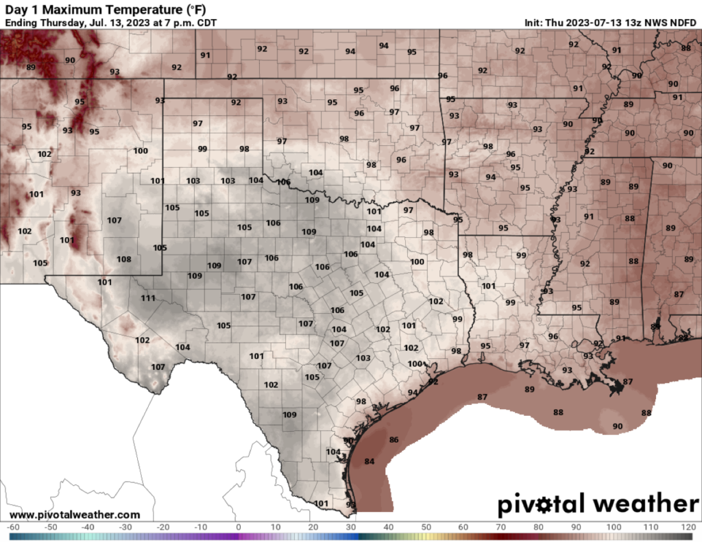
For Texas, the southern Plains, the mid-South, Gulf Coast and Florida, intense heat is combining with tropical moisture to bring hazardous heat indexes. Away from the coastline, most of Texas will see air temperatures in the 100-to-105-degree range Thursday, with lower to mid-90s elsewhere across Oklahoma, Kansas, Arkansas, Mississippi, Alabama and Louisiana. The temperatures alone probably won’t break many records.
But extreme humidity, with dew points in the 70s, will spread over most of the region. That means that every cubic meter of air will be holding roughly half a shot glass’s worth of moisture. The atmosphere, which will be closer to saturation, won’t be able to evaporate sweat off a person’s skin and allow evaporative cooling to regulate body temperature. As a result, heat stress will grow, and heat indexes of 105 to 112 degrees will be widespread. A few locations will feel like 115 degrees or worse.
In Florida, a main culprit has been the ongoing historic marine heat wave. A number of spots off the southwest Florida coastline are seeing water temperatures of 95 degrees or greater. That is adding exceptional amounts of moisture into the air.
Miami had a heat index of 110 degrees on Monday and 108 on Tuesday. The city is at 32 days in a row with a heat index over 100 degrees, and a record 11 consecutive days with a heat index topping 105. Only meager improvement is likely in the days ahead, as afternoon thunderstorms return to the forecast.
What’s causing the heat?
Triggering the heat is a sprawling ridge of high pressure, which acts as a force field to deter any storms and deflect the jet stream to the north. That’s allowing sinking air to heat up and dry out, with readings spiking 5 to 15 degrees above average. On Thursday, that heat dome reached from off the coast of the Baja Peninsula and Southern California up to the eastern North Pacific and over to the Gulf of Mexico.
By the middle of next week, however, it’s slated to intensify and consolidate, all while shifting toward New Mexico and Texas. It will anchor itself over the southern Plains and Rockies, spreading its sphere of influence across most of the western, south-central and southeastern U.S. Sunshine will pour down unimpeded, baking the ground even more.
Jason Samenow contributed to this report.