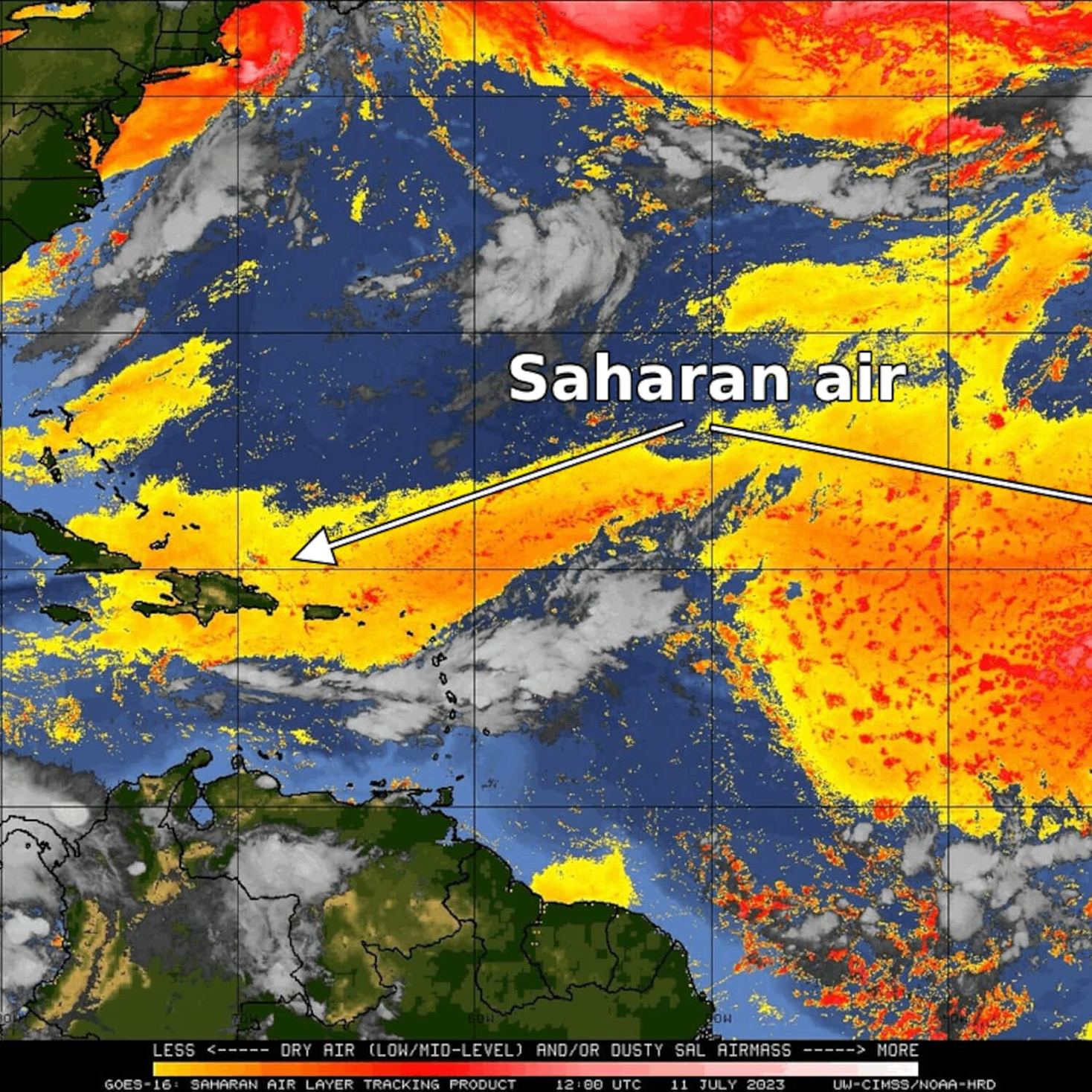
Hazy skies returned to parts of the East Coast over the weekend, but this time it wasn’t because of wildfire smoke in Canada. A sprawling plume of dust — originating from Africa — began to make its presence known in the Caribbean and Florida, a weather satellite revealed Monday.
The enormous dust plumes — known as Saharan Air Layers — have spread not only to the eastern United States but also to Spain and the Mediterranean, according to the Copernicus Climate Service of the European Union.
The dust, known to make sunrises and sunsets more colorful, is expanding over the Atlantic Ocean after only small amounts were present last month.
The lack of dust was probably among the contributors to record-warm ocean waters in recent weeks. In the absence of the dust, the sun could heat the ocean surface unimpeded. The dust’s return may limit ocean warming in the weeks ahead.
The dust not only reduces ocean warming but can also impede the development of tropical storms and hurricanes. The increase in dust in the last two weeks is probably among several reasons tropical storms haven’t developed after a fast start to the hurricane season in June.
How do these dust plumes develop?
Saharan Air Layers are formed by light, dry sands and other minerals. They require winds to loft and carry them thousands of miles.
These winds typically are most common between spring and early fall when atmospheric disturbances — known as tropical waves — begin trekking westward across Africa and enter the Atlantic.
Like the wildfire smoke across North America of late, the fine particles contained in Saharan dust can be harmful to breathe in large quantities, especially for those with respiratory issues and nearer the source.
In the Caribbean and United States, the dust usually arrives at high altitudes rather than near the ground, so its most noticeable effects are milky midday skies and vivid sunrises and sunsets.
The effect of dust on ocean temperatures and hurricanes
Scientists pay particular attention to the dust because it affects ocean temperatures and tropical storm and hurricane development.
At the end of June, Michael Lowry, a hurricane specialist for Miami television affiliate for WPLG, shared an analysis on Twitter highlighting the absence of dust during the month.
“Less dust generally means a toastier Atlantic,” he tweeted.
Sea surface temperatures — or SSTs — have been exceptionally warm across much of the globe recently, and especially in the Atlantic. While there are multiple contributing factors, including human-caused climate change and a developing El Niño event, a lack of dust is considered a key contributor.
But things are changing.
“The dust drought is over,” tweeted Jeff Berardelli, chief meteorologist at Tampa television affiliate WFLA-TV. And this uptick in dust is potentially good news for limiting hurricane development.
The dust layers contain about 50 percent less moisture than a more humid atmosphere. Moisture is a key ingredient for storms and a drier environment favors collapsing thunderstorm updrafts, which are detrimental to their organization.
In addition, the dust layer requires strong upper level winds to reach North America. Such winds are unfavorable to storm development.
Finally, the warm temperatures immersed within the dust layers — several thousand feet above the ocean surface — tend to reduce the necessary atmospheric instability needed for showers and storms.
As additional bursts of dust move westward off Africa for the next week or two, these three factors are likely to combine to keep tropical storm activity low.
However, as the Atlantic Ocean temperatures remain at record levels, disturbances may attempt to develop where the dust is absent. The National Hurricane Center is monitoring a batch of showers and storms east of Bermuda, which has some potential to develop into a storm.
Moreover, these dust layers seldom last forever and sometimes wane during late August and September, toward the peak of hurricane season. Last year, dust contributed to an August without a single named storm before hurricane season roared back to life in September and October.
Because of this year’s very warm Atlantic waters, forecasters are now predicting a normal to above normal hurricane season, reversing early predictions for a quiet one.
Jason Samenow contributed to this report.


