In the Arizona desert, researchers are learning so much more about the peoples who have inhabited this land since antiquity
Text by Alastair Lee Bitsóí
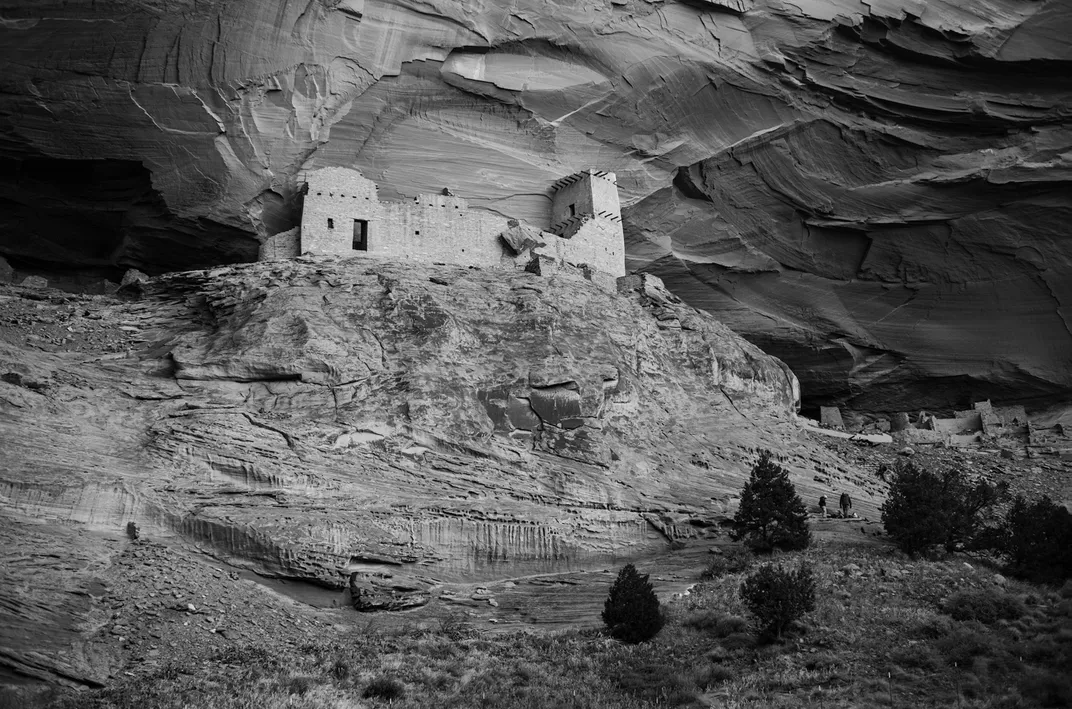
The Canyon de Chelly National Monument, on the Navajo Nation in northeastern Arizona, encompasses 83,000-odd acres of sandstone peaks and plateaus towering above waterways dotted with pines, junipers, aspens and cottonwoods. Viewed from the sky, the canyon takes the shape of a turkey’s foot—fitting, since wild turkeys have lived here for centuries. The area’s best-known formation may be Spider Rock, a red sandstone dagger stabbing 750 feet up into the Southwestern sky. But perhaps its greatest and most mysterious feature is a vast complex of 165 or more rooms, some hewn by the Indigenous peoples who have lived here for more than a thousand years, drawn by fertile soil fed by springs and streams, abundant wild game, and natural protection from the elements.
/https://tf-cmsv2-smithsonianmag-media.s3.amazonaws.com/filer_public/cc/d3/ccd348ff-d8e2-416e-9ca1-03f839322c1d/2_mummy_cave_approach.jpg)
/https://tf-cmsv2-smithsonianmag-media.s3.amazonaws.com/filer_public/4b/a1/4ba14dfd-b7a6-406a-a6e2-933dad1938b9/newmap.jpg)
To their successors, the Navajo, or Diné, this most sacred complex is known as Tse Yaa Kin, the House Under the Rock—a place of deep reverence for the remnants of an ancestral culture. On a hot September day, I joined a scientific mission to the site. Though I’m Diné myself, this was my first visit. And I had some trepidation, because to many Indigenous people, Tse Yaa Kin, known also as Mummy Cave, is a holy site considered off-limits.
To cross the sandy wash from the southwest requires four-wheel drive; when a truck gets stuck in the mud or the sandy soil, you use a winch to tow it out. Now and then, feral horses emerged from the cottonwood trees. As the road unfurled, it revealed peach orchards and cornfields ready for the harvest. Ancient Native homesteads and cultural sites, including the famous White House Cliff Dwellings, popped into view, then receded as I moved deeper into the canyon, accompanied by Josh Ramsey, a veteran National Park Service (NPS) archaeologist.
After two hours, Tse Yaa Kin appeared around the bend, its alcoves offering tantalizing shelter from the September sun. People inhabited this land more than 4,000 years ago, but the human-made structures date to between A.D. 300 and 1300, when a series of Native groups built and occupied a small city’s worth of homes, meeting houses and places of worship in these cliffs. Starting more than 1,000 years ago, the inhabitants adorned the walls of the complex with decorative earthen plasters in white and occasionally green. At the center of the complex is the most elevated room, which Diné and other tribes consider the holiest spot in this remarkable site.
/https://tf-cmsv2-smithsonianmag-media.s3.amazonaws.com/filer_public/74/53/7453168a-628f-4d1d-934a-10093aeacce6/10_mummy_cave_southside_and_valley.jpg)
/https://tf-cmsv2-smithsonianmag-media.s3.amazonaws.com/filer_public/62/08/6208ebaa-d2ff-4394-b86e-181326b3a182/19_view_in_mummy_cave_kiva_2.jpg)
Suddenly, around the 13th century, all the inhabitants left, most likely fleeing a drought, geologists say; through the succeeding centuries, the natural caves protected many of the constructed dwellings inside. In 1882, Colonel James Stevenson, pursuing ethnographic work on behalf of the Smithsonian Institution, led the first team of Western archaeologists to this site, where he found two sets of human remains, wrapped in yucca cordage, which had been preserved through desiccation. Stevenson’s team quickly dubbed the site the “Mummy Cave,” which is how it’s still widely known. Ever since, anthropologists and archaeologists have come here to study the remarkable history contained in these caves. Yet until now, scholars have never done a full archaeological and architectural survey of the site.
Tse Yaa Kin remains a powerful place to many Indigenous people who live in the canyon and throughout the Southwest. But in recent years, it’s become clear that the canyon’s natural ecosystems, like its cultural sites, are threatened by invasive species, erosion and the impacts of a changing climate. Since 2022, a group of 15 researchers and students led by Ramsey of the NPS and Angelyn Bass, an anthropologist at the University of New Mexico, has been surveying the entirety of Tse Yaa Kin—hiking, climbing and occasionally rappelling down the steep walls of sandstone. Using digital photography and the remote sensing method known as lidar, the researchers aim to map the complex for the first time, in part to determine which portions are most vulnerable to decay, and therefore most in need of protection. (Eventually, the team could recommend some structural stabilizing work, perhaps including the central tower complex.) And by submitting those precious plasters to electron microscopy, they are learning about their composition and the people who lived within these walls centuries ago.
As I approached Tse Yaa Kin in a truck, accompanied by Ramsey, the research team came into view: little dots in the distance, buzzing to and fro among the sacred alcoves, near where Ramsey, Bass and other researchers had pitched their makeshift camps. Their work is both hard and delicate: They climb up the canyon’s walls with their backpacks full of tools and gently collect flakes of fallen plasters from the ground, to study the fine finish that has preserved them. “All that’s left that is expressive of the people who lived here are the plasters,” Bass said, pointing to the handprints and fingerprints left in these decorative touches. The plasters, Bass argued, bring us closer to these ancestors: “They have a voice.”
/https://tf-cmsv2-smithsonianmag-media.s3.amazonaws.com/filer_public/87/50/87503cc6-eff9-47a3-b5a6-fd3e601c06ea/7_climb_to_munny_cave.jpg)
/https://tf-cmsv2-smithsonianmag-media.s3.amazonaws.com/filer_public/3f/70/3f70adfc-0ae7-40f4-a3ae-79310c98513e/37_lidar.jpg)
/https://tf-cmsv2-smithsonianmag-media.s3.amazonaws.com/filer_public/b8/88/b888645d-6146-4ae8-aa0c-82844dd47ab9/39archeologist_josh_ramsey.jpg)
Over the next two days, I watched the researchers work and spent time with them over meals by the camping stove, which sat among junipers and piñons along the banks of a wash. On the third day, threats of monsoonal rains cut short my trip, and the researchers sought refuge outside the canyon, their important work interrupted by the intensifying weather of climate change—the same force that threatens these caves.
Bass, whose academic background is in art history and historic preservation, was clearly excited to examine the complex’s architectural and design elements in detail. She is especially fascinated by the earthen plasters, an ancient art form she’s been studying for 30 years. She recalled an episode from when she was around 20 and working as an interpreter at Mesa Verde National Park in Colorado, on a day when the site had no visitors. Bass sat in one of the park’s ancient alcoves and watched a conservator working on “a beautiful plaster that had bighorn sheep going across it,” she said. “And I knew then that’s what I wanted to do.”
The decorative plasters are just one element attesting to the history of the people who have lived here. Artifacts, including tools, and rock art depicting hunters, antelopes, goats and more tell the story of the Archaic people, who inhabited these lands from 2500 B.C. to 200 B.C. The baskets found throughout the cave complex—preserved all this time with help from the dry air—remind visitors that the Basketmaker people built elegant, complex public spaces in these canyon walls between 200 B.C. and A.D. 750. And the Ancestral Pueblo people, who dwelled here between A.D. 750 and 1300, were also sophisticated builders. The Hopi farmed in the valley seasonally from the 1300s to the 1600s, and the Hopi and the Pueblos still maintain their ties to the site today. Since the early 1700s, the Diné people have lived in the canyon, where they farm and herd sheep and goats through fields, sometimes sheltering herds within the ghostly complex.
For the Diné, the canyon was a stronghold against the westward expansion of the U.S. government in the early and mid-1800s. Then, in the 1860s, one of the most tragic episodes in Diné history occurred here, when the American government successfully besieged the Diné right where I stood with Bass and her team. Some historians describe this siege as the defining moment in a genocidal campaign that forced thousands of Diné people to march hundreds of miles, at gunpoint, from their homelands here in Arizona to Hweeldi, or Fort Sumner, in present-day New Mexico. Along the way, hundreds died; government forces, meanwhile, destroyed our cornfields and peach orchards and slaughtered our livestock. We Diné refer to this forced relocation as the “The Long Walk.” Though around 40 families live within the limits of the monument today, for many, the displacement remains an open wound.
/https://tf-cmsv2-smithsonianmag-media.s3.amazonaws.com/filer_public/ac/bb/acbb897e-72a9-40e0-ba09-032e80da9d59/19a_paintings_in_mummy_cave_kiva.jpg)
/https://tf-cmsv2-smithsonianmag-media.s3.amazonaws.com/filer_public/3f/f0/3ff0c736-bd2c-4cfa-85a7-2c5377bf3d8d/7mummy_cave_south_side_logs_copy.jpg)
/https://tf-cmsv2-smithsonianmag-media.s3.amazonaws.com/filer_public/6a/71/6a71ccab-1cb5-4637-8b87-767e79e1bd4a/13_mummy_cave_tower_wmb_photoshoot.jpg)
Though the Navajo Nation government now oversees this sacred area in collaboration with the NPS, some Diné families consider the ancestral sites to be tainted ground. For those families, and indeed for me as a Diné writer, these lands are filled with spirits, not all of them benign. As a result, I did not undertake this reporting lightly: To walk on this land, and particularly to enter any rooms of the cave complex, requires extreme caution—because to enter is, in essence, to disturb the home of ancient spirit energies, and that can bring dangers. Afterward, it is wise to offer songs or prayers for safe passage. In the end, I decided that I must respect these spirits’ homes—that I would not, and should not, climb to the holiest parts of the complex. Instead, I watched the team work from below, and when I left the canyon, feeling conflicted about the whole experience, I wondered whether simply visiting had violated a sacred code.
/https://tf-cmsv2-smithsonianmag-media.s3.amazonaws.com/filer_public/0d/6c/0d6c005d-1936-4bf1-a3ae-96468df18580/24_scientist_in_mummy_cave.jpg)
/https://tf-cmsv2-smithsonianmag-media.s3.amazonaws.com/filer_public/74/79/74794827-0e0f-46fa-abba-09c5498dfe4a/17_mummy_cave_tower_interior_ceiling.jpg)
Later, somewhat shaken from my visit, I got in touch with Joseph Pablo, a Diné cultural practitioner based in Naschitti in the Navajo Nation. Pablo pointed out that even though I did not go up to the heart of the site, as the researchers did each day, I did share meals with the team, and they may have exposed me to the energy of the dead.
“You will get sick from it,” Pablo warned me. “You will get dizzy; you will get cramps.” He said it is common practice among Native peoples to avoid touching the remains of pottery at the site, or even to eat food within view of Tse Yaa Kin. He added that if I spent too much time on this type of reporting, it could harm my being more deeply in the future.
Pablo led me through a set of healing rituals used traditionally after exposure to the dead. In the Diné language, the term hozho refers to a balanced wellness—spiritual, mental, emotional and physical. Without Pablo, I wondered whether my hozho would have returned. I wondered, too, what hozho will mean in the future at this site, and whether Native groups will ever regain true control over their ancestral lands, perhaps bringing some peace to the spirits who dwell in these walls.
Bass and her colleague Douglas Porter, an architectural conservator at the University of Vermont, say they feel their own urgency to map this holy ground. “Part of the work we’re doing is documenting these places against the threat of loss,” Porter says. Bass adds, “The structures are fragile.” They are especially vulnerable to wind abrasion and water running off the sheer cliffs, where overhangs are eroding. Given the likely damage to Tse Yaa Kin in the future, Porter says, the question becomes: “What do we want to preserve about the site, should something terrible happen and we lose it?” Thanks to comprehensive mapping and lidar imaging, the physical topography will be recorded for posterity. The spirits are less easy to capture, or to flee.
Source: https://www.smithsonianmag.com/history/canyon-of-the-ancestors-180985955/