Jim Blackburn likes to drive out-of-town visitors across the high arch of the Fred Hartman Bridge for the best view of the Houston Ship Channel, a 52-mile-long waterway crowded with the continent’s largest collection of petrochemical plants and oil refineries. Sprawling over what had been low coastal marshland is a jumble of pipelines, smokestacks, storage tanks and cargo ships. For the full impact, the environmental lawyer sometimes brings guests after sunset.
“You come over this bridge at night, and you see all the lights and steam and the flares going off all over the place,” he said as his car crested the span. “One time, I had an Episcopal priest from Seattle with me. She looks down at all this and says, ‘This is what hell looks like.’”
Blackburn let out a sour chuckle. The ship channel’s transformation into a true hellscape, he said, is yet to come. “Throw a real hurricane at this and it’ll be the largest environmental disaster in US history,” he said.
Blackburn, who teaches at Rice University, has been prophesying this calamity for more than a decade. What might have seemed a grim fantasy a few years ago looks increasingly likely with each storm that rakes across the industrial corridors of Texas and Louisiana.
His end-times vision begins with a mild-mannered tropical storm taking shape somewhere in the mid-Atlantic. As it gathers strength in the warm waters of the Gulf of Mexico, the storm builds into a hurricane hundreds of miles wide with winds topping 130 mph. Instead of striking just east of Houston, as Hurricane Ike did 2008, or veering over to Louisiana, as Laura did last year, this storm plows straight into the heart of Galveston Bay, pushing it into a nearly 30-foot-high bulge and dropping it on the bay’s heavily developed west side, an area that’s home to more than 800,000 people.
Thousands may die from the initial burst of wind and water, but the real terror begins when the storm surge squeezes into the Houston Ship Channel. The surge, he said, will break ships off their moorings, cleave oil pipelines, and pummel thousands of storage tanks holding the raw material for everything from paint thinners to jet fuel. This toxic stew of oil, chemicals, and debris will flood urban bayous, spill into neighborhoods, and eventually wash back into the bay.
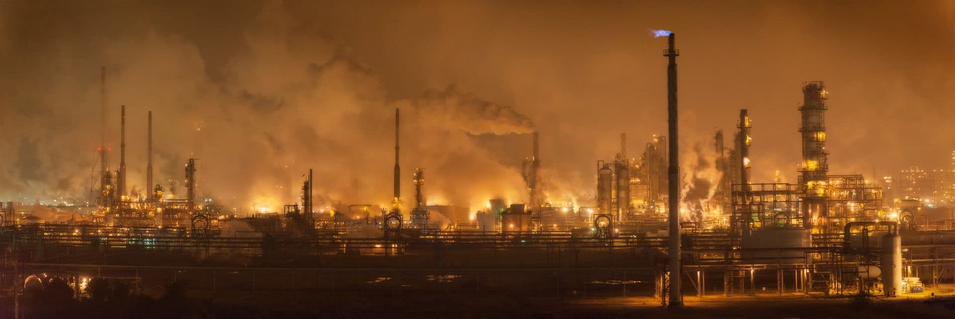
Oil refineries along the Houston Ship Channel. (Louis Vest via Flickr; CC BY-NC)
“This is what hell looks like.”
Blackburn’s bleak prediction, developed with computer modeling by Rice’s Severe Storm Prediction, Education and Evacuation from Disaster (SSPEED) Center, loses doubters with each passing storm.
“The storms and types of weather we’re having are more extreme,” said MaryJane Mudd, executive director of East Harris County Manufacturers Association, an alliance of chemical producers along the ship channel. “We are having to prepare for things we’ve never considered before.”
Despite the risks, the industry has been slow to adapt. Companies are not building bigger floodwalls, altering facility designs, or shifting development inland. Federal and state governments are doing little to push industries. Regulations remain frozen as the climate warms, increasing the likelihood of stronger and more frequent storms.
Industry leaders and regulators are instead banking on a nearly $30 billion storm protection project known as the Ike Dike. Named for the hurricane, the vast system of walls, gates, and levees would make Galveston Bay a veritable fortress that could be sealed up when hurricanes threaten.
It’s ambitious and expensive, but Blackburn says it will be too little, too late. Likely to take the better part of two decades to build, the Ike Dike won’t hold up to the worst hurricanes. “Look, it needs to be built,” he said. “But it needs to be built for the bigger storms to come. It will be way outdated once it’s constructed.”
MEASURING RISK
The risks hurricanes pose to industrial areas aren’t limited to Houston. More than 4,876 sites that handle toxic chemicals sit in storm- and flood-prone areas of Texas and Louisiana, a Bulletin of Atomic Scientists and Massachusetts Institute of Technology analysis of flood plain and industrial data shows.
Home to the bulk of the country’s petrochemical infrastructure, the two states are under growing risk from rising seas, hurricanes, river flooding, intense rainfall, and other threats posed by climate change. Of those sites in Texas and Louisiana, 1,987 were in locations with moderate risk and 2,889 were at high risk.
The Houston area has about 900 facilities with toxic chemicals in areas at risk to floods from storms. New Orleans has more than 150. “We know the risk is high in the ship channel and around Houston, but our analysis emphasizes that this is a risk that’s prevalent in a lot of places,” said Adam Schlosser, an MIT climate risk researcher who led the analysis. “Hopefully, this will raise eyebrows and call attention to how severe these issues are.”
The Bulletin-MIT analysis looked at sites listed in the US Environmental Protection Agency’s Toxics Release Inventory, a database in which facilities self-report hazardous chemical releases in the air, in water, or on land. Most of the more than 21,000 such facilities across the country are involved in large-scale chemical production, manufacturing, mining, and waste treatment.