
The remnants of Hurricane Ida brought a tropical deluge of unprecedented proportions to the New York City metro area on Wednesday night into Thursday.
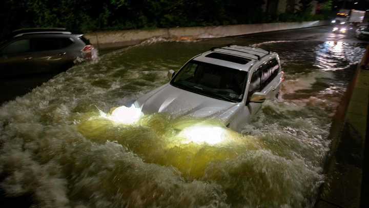
Driving the news: The flooding that resulted from the heavy rainfall shut down Newark Airport, and turned city and country roads in all five boroughs and surrounding areas of New Jersey and Pennsylvania into rivers.
Why it matters: The historic deluge clearly demonstrates that climate change is winning the battle between a rapidly shifting climate and outdated infrastructure.
This event may now become the prime example for U.S. efforts to better adapt to climate change.
Studies have shown that warming air and ocean temperatures are increasing the odds and severity of heavy precipitation events, and leading to changes in hurricanes that are making them more powerful and damaging.
For every 1°C (1.8°F) increase in temperatures, the atmosphere can hold 7% more moisture, which helps fuel storms like Hurricane Ida.
State of play: A state of emergency is in effect for New York City, as at least 14 fatalities have been reported in the city and New Jersey, per the New York Times.
Threat level: The National Weather Service forecast office in New York City issued its first-ever “flash flood emergencies” during this event: one for northern New Jersey and one in New York City itself, as phenomenal rainfall rates overwhelmed drainage systems.
This is the agency’s most severe type of flood warning, reserved for cases of ongoing, catastrophic flooding with potential loss of life.
By the numbers: All-time rainfall records were shattered, with the city crushing a milestone it set just over a week ago by receiving 3.15 inches of rain in one hour at Central Park, and 5.20 inches in three hours.
Newark Airport in New Jersey recorded half an inch of rain in six minutes Wednesday evening. Within 23 minutes, 1.53 inches had fallen, according to an NWS meteorologist. In one hour, 3.24 inches of rain accumulated. In total, Newark received 8.41 inches of rain, which set an all-time record for the wettest day.
The three-hour rainfall total in Central Park qualifies as a 500-year rainfall event — though the past is an increasingly poor guide to both the present and the future, as climate change is making such rare events more frequent and likely to occur, studies show.
Details: The rainfall shut down the New York subway system, which is notoriously susceptible to flash flooding, with closures continuing as of Thursday morning.
Closures were also reported on regional rail networks, the busiest in the nation, and some Amtrak routes.
In the subway, footage of the flooding resembled waterfalls as water spilled into stations. Streets, including Queens Boulevard, were more fit for kayaks than city buses by late Wednesday night.
The intrigue: Two days in advance, the National Weather Service had explicitly forecast a dangerous flash flood scenario would unfold. However, pinpointing the exact zones of heaviest rains remains tricky, and some New York City residents may have been unaware of the scale of the flood threat.
What’s next: Acknowledging the growing threat from climate change, New York Gov. Kathy Hochul told Spectrum 1 news on Thursday morning that she will seek for the subway system to be modified to prevent a similar flood from occurring again.
“I want this system fortified so this does not become anything more than a regular occurrence. New Yorkers deserve better than that,” the Democratic governor said. The subway is under state, not city, control.
The bottom line: The epic deluge will stand, perhaps not for long, as the most severe flash flood event in New York City history. The question now is how the local, state and federal governments will respond to this to prevent the next one from being so damaging and deadly.